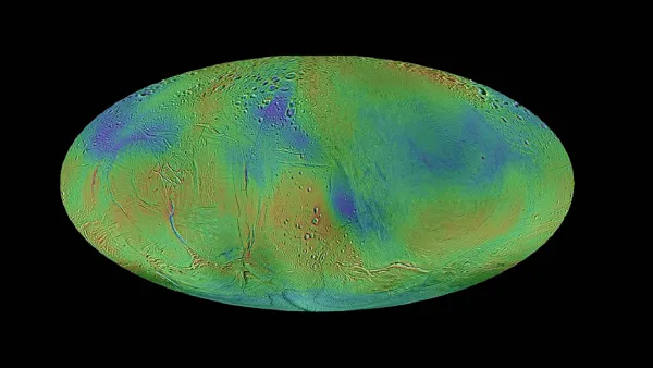
A team of scientists has produced the first complete and comprehensive global topographic map of Saturn’s active icy moon Enceladus, revealing that it is even more distorted than previously thought.
In an article published in the journal Icarus, USRA’s Paul M. Schenk of the Lunar and Planetary Institute and William B. McKinnon, Professor of Earth, Environmental, and Planetary Sciences and fellow of the McDonnell Center for the Space Sciences, both at Washington University in St. Louis, show that this small ocean world is being deformed by internal processes well outside the areas of active venting at the South Pole.
The most prominent features in the new map are oval depressions that are 100 kilometers (~62 miles) wide and up to 1.5 kilometers (~1 mile) deep. In 2009, the authors published a preliminary topographic map of less than half the surface of Enceladus that showed several of these depressions. However, their new globally complete data have revealed that these large oval basins are mostly on one side of Enceladus and that a larger more complex depression now can be seen on the other hemisphere.
